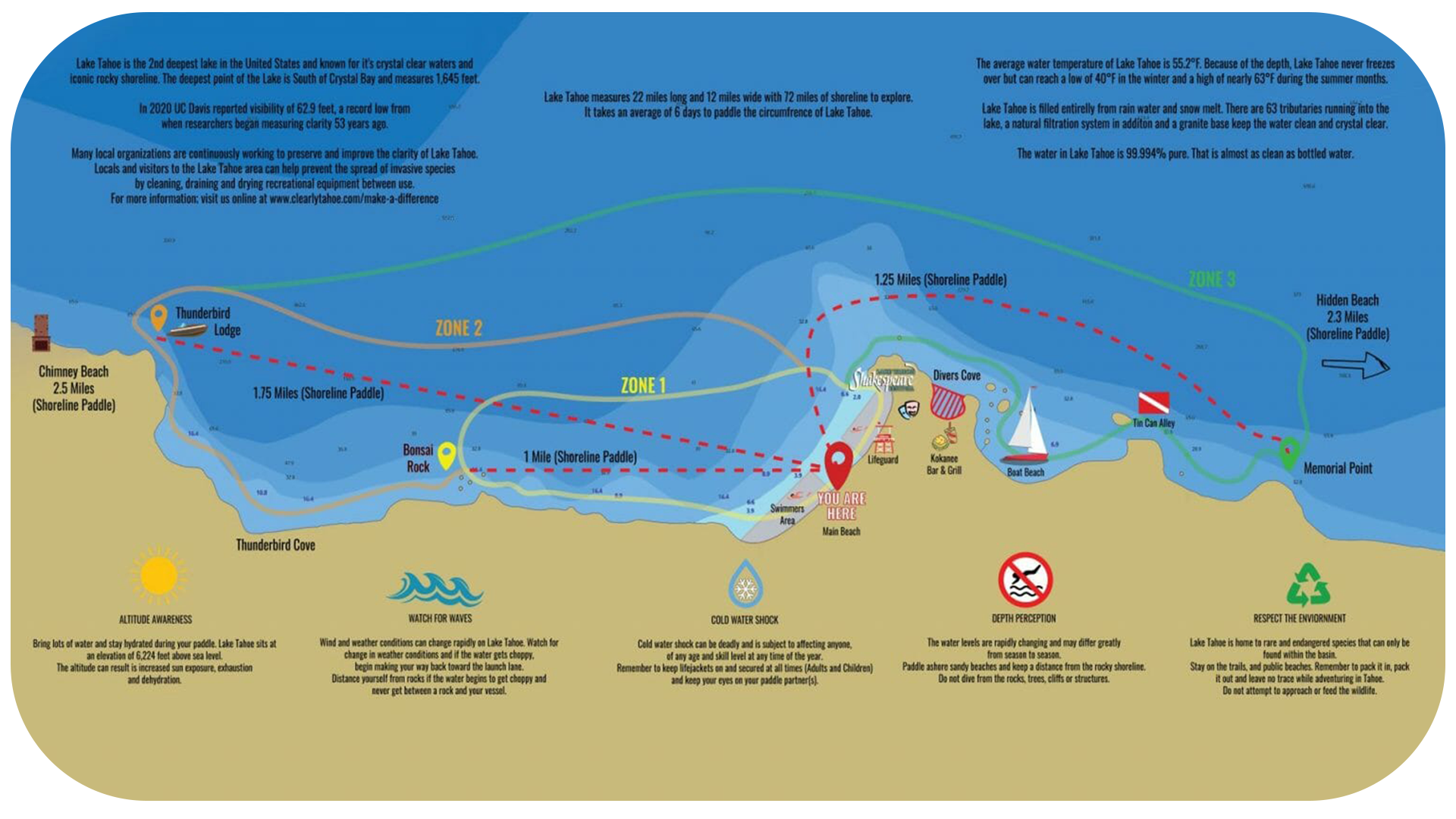
Vessel Limitations
ZONE 1:
Transparent Paddleboard
Completely Clear Kayaks
(Wind and weather permitting.)
ZONE 2:
Classic Canoe
(Wind and weather permitting.)
ZONE 3:
Clear Bottom Kayaks
Wooden Paddleboards
(Wind and weather permitting.)
NO LIMITATIONS:
Sit-on-Top Kayaks
Standard Paddleboards
Pedal Kayak
Touring Kayak
Tandem Island
Floating Lounge
(Wind and weather permitting.)
Safety Tips
ALTITUDE AWARENESS
Bring lots of water and stay hydrated during your paddle. Lake Tahoe sits at an elevation of 6,224 feet above sea level. The altitude can result is increased sun exposure, exhaustion and dehydration.
WATCH FOR WAVES
Wind and weather conditions can change rapidly on Lake Tahoe. Watch for change in weather conditions and if the water gets choppy, begin making your way back toward the launch lane. Distance yourself from rocks if the water begins to get choppy and never get between a rock and your vessel.
COLD WATER SHOCK
Cold water shock can be deadly and is subject to affecting anyone,of any age and skill level at any time of the year. Remember to keep lifejackets on and secured at all times (Adults and Children) and keep your eyes on your paddle partner(s).
DEPTH PERCEPTION
The water levels are rapidly changing and may differ greatly from season to season. Paddle ashore sandy beaches and keep a distance from the rocky shoreline. Do not dive from the rocks, trees, cliffs or structures.
RESPECT THE ENVIORNMENT
Lake Tahoe is home to rare and endangered species that can only be found within the basin. Stay on the trails, and public beaches. Remember to pack it in, pack it out and leave no trace while adventuring in Tahoe. Do not attempt to approach or feed the wildlife.
Fun Facts
Lake Tahoe is the 2nd deepest lake in the United States and known for it’s crystal clear waters and iconic rocky shoreline. The deepest point of the Lake is South of Crystal Bay and measures 1,645 feet.
In 2020 UC Davis reported visibility of 62.9 feet, a record low from when researchers began measuring clarity 53 years ago.
Many local organizations are continuously working to preserve and improve the clarity of Lake Tahoe. Locals and visitors to the Lake Tahoe area can help prevent the spread of invasive species by cleaning, draining and drying recreational equipment between use.
For more information; visit us online at https://clearlytahoe.com/sustainability/
Lake Tahoe measures 22 miles long and 12 miles wide with 72 miles of shoreline to explore.
It takes an average of 6 days to paddle the circumference of Lake Tahoe.
The average water temperature of Lake Tahoe is 55.2°F. Because of the depth, Lake Tahoe never freezes over but can reach a low of 40°F in the winter and a high of nearly 63°F during the summer months.
Lake Tahoe is filled entirely from rain water and snow melt. There are 63 tributaries running into the lake, a natural filtration system in addition and a granite base keep the water clean and crystal clear.
The water in Lake Tahoe is 99.994% pure. That is almost as clean as bottled water.
